Part 26 Miscellaneous signs indicating services and local facilitiesI1
England, Wales and Scotland
Sign table — Schedule 12, Part 26
(1) Item | (2) Description | (3) Diagram | (4) Permitted variants |
|---|---|---|---|
| 1 | Diagram 2917.1 Availability of motorway service areas ahead, including services for lorries only (truckstop), with distances in miles and geographical names |  | 1. The geographical names of the service areas and the words “NO SERVICES” may be varied or omitted as appropriate; 2. The lorry symbol and “only” may be omitted; 3. The numerals expressing distance may be varied with the only permitted distance that is less than a mile being “⅔ m” with distances greater than 1 mile being expressed to the nearest mile; 4. Motorway numbers, with or without compass points, may be varied or omitted as appropriate; 5. The number of service areas indicated may be varied; |
| 2 | Diagram 2917 Availability of motorway service areas ahead with distances in miles and names of operators |  | 1. The names of the service area operators and the words “NO SERVICES” may be varied or omitted as appropriate; 2. The numerals expressing distance may be varied with the only permitted distance that is less than a mile being “⅔ m” with distances greater than 1 mile being expressed to the nearest mile; 3. Motorway numbers, with or without compass points, may be varied or omitted as appropriate 4. The number of service areas indicated may be varied; |
| 3 | Diagram 2918 Distance to next motorway service area |  | The numeral may be varied with the distance expressed in miles to the nearest mile |
| 4 | Diagram 2918.1 Sign placed on or near a motorway indicating that services are not available |  | |
| 5 | Diagram 2330 Sign placed on or near a primary or non‑primary route indicating that services are not available on motorway ahead | 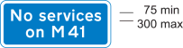 | 1. The motorway number may be varied and include a compass point as appropriate; 2. The motorway number may be varied to “motorway” |
| 6 | Diagram 2308.1 Junction ahead on a primary or non-primary route leading to a small town or village not on a main through route, |   | 1. The place name may be varied or omitted; 2. “local” must be varied to “Local” when the place name is omitted; 3. “local facilities” may be omitted; 4. A distance in accordance with Part 3 of Schedule 18 may be added except that the distance must not be expressed in yards; 5. The direction in which the arrow points may be varied and where the arrow points ahead and there is a single line of legend, the arrow shown by diagram B at item 1 of the table in Part 24 of this Schedule must be used; 6. Symbols |
| 7 | Diagram 2309.1 Direction and distance in miles to a small town or village offering facilities indicated on the sign shown in item 5 of this table |  | 1. The place name may be varied or omitted; 2. “local” must be varied to “Local” when the place name is omitted; 3. The direction in which the sign points may be reversed; 4. The distance may be varied to another in accordance with Part 3 of Schedule 18 except that the distance must not be expressed in yards |
Annotations
Textual amendments
- F1
Words in Sch. 12 Pt. 26 Table substituted (S.) (23.5.2022) by The Traffic Signs Amendment (Scotland) Regulations and General Directions 2022 (S.S.I. 2022/111), regs. 1(2), 7(6)(a)
- F2
Sch. 12 Pt. 26 Table item 6: diagram substituted (S.) (23.5.2022) by The Traffic Signs Amendment (Scotland) Regulations and General Directions 2022 (S.S.I. 2022/111), regs. 1(2), 7(6)(b), sch.
- F3
Words in Sch. 12 Pt. 26 Table omitted (S.) (23.5.2022) by virtue of The Traffic Signs Amendment (Scotland) Regulations and General Directions 2022 (S.S.I. 2022/111), regs. 1(2), 7(6)(c)
Commencement
- I1
Sch. 12 Pt. 26 in force at 22.4.2016, see reg. 1(b)